<?xml version="1.0" encoding="UTF-8"?>
<feed xmlns="http://www.w3.org/2005/Atom">
  <title type="text">Acadiana Historical</title>
  <updated>2026-03-04T22:42:48+00:00</updated>
  <generator uri="http://framework.zend.com" version="1.12.20">Zend_Feed_Writer</generator>
  <link rel="alternate" type="text/html" href="https://mail.acadianahistorical.org/"/>
  <link rel="self" type="application/atom+xml" href="https://mail.acadianahistorical.org/items/browse?output=rss2"/>
  <id>https://mail.acadianahistorical.org/</id>
  <author>
    <name>Acadiana Historical</name>
    <uri>https://mail.acadianahistorical.org</uri>
  </author>
  <link rel="hub" href="https://pubsubhubbub.appspot.com/"/>
  <entry>
    <title type="html"><![CDATA[Hurricanes Batter Cameron Parish Cemeteries: Little Chenier Attempts to Defy the Storms]]></title>
    <summary type="html"><![CDATA[<img src="https://mail.acadianahistorical.org/files/fullsize/265ee6f94a20375b82a024271802568c.jpg" alt="Overview of Little Chenier" /><br/><p>One of the lost and forgotten cemeteries is Little Chenier Cemetery in Creole, Cameron Parish. Located on Big Burn Road off the main Little Chenier Road, the cemetery is small but in an easily accessed clearing. The area is known for hunting camps and is easily evident with the large pile of bird carcasses on the opposite side of the road. Past hurricanes have damaged the area, and Little Chenier is no exception. A metal fence at one point marked the cemetery boundary, but now only a few posts and the gate remain.</p><p>The cemetery does not look cared for, although some of the headstones look as though they were replaced recently. Two headstones are marked with “Smith Woodard Lake Charles LA.” Upon further research, I spoke with the owner of the now Bourque Smith Woodard Memorials, and for over half a century, the business has helped clean up hurricane-hit cemeteries along the Gulf Coast. Since FEMA started providing financial assistance to hurricane hit cemeteries, other companies have jumped on board and even specialize in cemetery disruption consulting. </p><p>Several headstones are handwritten, one is curiously outside the original fence, and one has famous relations. Victoria Broussard lived to be 101 years old and had a very famous second cousin, Abraham Lincoln. Although Victoria never met her famous cousin, it is still amazing how Lincoln’s family ties travel to south Louisiana; disturbing to think that these famous associations might never be known because of a lack of upkeep. Think about how many have already been lost.</p><p><em><strong><a href="https://mail.acadianahistorical.org/items/show/177">For more (including 12 images&#32;&amp;&#32;1 audio file) view the original article</a></strong></em></p>]]></summary>
    <published>2022-05-06T07:56:06+00:00</published>
    <updated>2026-03-04T22:42:48+00:00</updated>
    <link rel="alternate" type="text/html" href="https://mail.acadianahistorical.org/items/show/177"/>
    <id>https://mail.acadianahistorical.org/items/show/177</id>
    <author>
      <name>Tanya Greene</name>
    </author>
  </entry>
  <entry>
    <title type="html"><![CDATA[Mount Zion Riverlake Cemetery: &quot;To Lie With Those Who Have No Mark&quot;]]></title>
    <summary type="html"><![CDATA[<img src="https://mail.acadianahistorical.org/files/fullsize/9b577bfc16ed6e6b91b7e161ce7dcd83.jpg" alt="To Lie With Those Who Have No Mark" /><br/><p>One of the lost and forgotten cemeteries is maybe not so lost, but unfortunately becoming forgotten. The cemetery is famous but a search on Google maps reveals a simple word to describe this place: Graveyard. Upon further inspection, however, an entire world opens up. The cemetery is located in the small community of Oscar, Louisiana in Point Coupee Parish. Traveling down Louisiana Highway One, the road to the cemetery is barely visible. Once on the small, dirt road, it appears uninviting and you expect to see “No Trespassing” signs. The road is surrounded by sugarcane fields and about one mile down, a small tree covered area appears to the left. Inching closer, you can see the reflective white of the stones appearing through the trees. The cemetery appears taken care of and quite beautiful. Large oak trees shade most of the grounds and each are surrounded by beautiful, thick cast iron plants. Many of the sites look old and worn but several appear to have received a recent facelift. Some new, marble headstones sit next to the originals that were concrete and handwritten. The headstones speak of their owners as mothers, fathers, babies, soldiers, sports fans, and many other individualities. A particularly interesting headstone marks that of L. J. Johnson who died in 1924. The carved symbol above his name represents the Mosaic Templars of America (MTA). The MTA was founded in 1883 in Arkansas by two former slaves. For African Americans experiencing the Jim Crow South, times were tough and the MTA provided illness, death, and burial insurance to its members. The organization adopted its name from the Biblical story of Moses emancipating the Hebrew slaves. The local chapter name, number, and location are located at the bottom of the headstone.</p><p>One invisible disclosure within the cemetery of particular importance, is that the people buried there were either slaves or the descendants of slaves from Riverlake Plantation. The same house, built 200 years ago, still stands overlooking the cemetery. After emancipation, many former slaves stayed and worked on the grounds. Up until the 1980s, descendants still lived in the old slave quarters. They lived, they loved, they went to school, went to church, and still worked and lived on the property. </p><p>The cemetery’s most famous resident is that of Ernest J. Gaines, Louisiana’s own famous author who based most of his story’s setting and premise on Riverlake Plantation. Gaines is surrounded by many of his family and friends. His biggest fear was that the cemetery would disappear amongst the encroaching agriculture. He wanted to be buried there in hopes that his fame would draw attention to the place and those he was surrounded by were never forgotten. In the 1990s, Gaines and his wife created the Mount Zion Riverlake Cemetery Association in order to care for the cemetery. The association along with the University of Louisiana at Lafayette’s Ernest J. Gaines Center hosted and successfully carried out a cleanup of the cemetery every year. Unfortunately, due to Gaines’ passing, other association board member deaths, and COVID-19, the last cleanup occurred in October of 2019 and there has been no mention of new cleanup dates. </p><p>Mount Zion Riverlake Cemetery is hugely important to Acadiana history. Instead of being labeled generically, it should be remembered as an open-air museum of African American slaves and their descendants who lived and left an indelible mark that should never be forgotten.</p><p><em><strong><a href="https://mail.acadianahistorical.org/items/show/170">For more (including 22 images&#32;&amp;&#32;1 audio file) view the original article</a></strong></em></p>]]></summary>
    <published>2022-05-05T08:12:28+00:00</published>
    <updated>2026-03-04T22:42:48+00:00</updated>
    <link rel="alternate" type="text/html" href="https://mail.acadianahistorical.org/items/show/170"/>
    <id>https://mail.acadianahistorical.org/items/show/170</id>
    <author>
      <name>Tanya Greene</name>
    </author>
  </entry>
  <entry>
    <title type="html"><![CDATA[St. Mary Parish Fields Overtaking Cemeteries: Raising Cane Around Midway]]></title>
    <summary type="html"><![CDATA[<img src="https://mail.acadianahistorical.org/files/fullsize/53cde5fb89e45145390582db06f94685.jpg" alt="Steel Crosses Bend to Weather and Time" /><br/><p>One of the forgotten cemeteries is Midway Cemetery located in Franklin, St. Mary Parish. Located right alongside State Route 317, most would miss this small treasure. Midway is little maintained, and the newest burial was conducted in 2011. Noted features are the makeshift crosses in place of headstones. Some simply have initials, others have a cross and what appears to be hanging hooks, along with a marble or concrete headstone. Many of Midway’s inhabitants were local farmers with large families. Nettie Hillard, 79, died in 1971 and left behind eight children, fifty-seven grandchildren, and thirty-nine great-grandchildren. Although Acadiana has strong Catholic roots, Mrs. Hillard and her family were Baptist farmers. Multiple denominations in the early twentieth century in Acadiana had many commonalities to include large families to help on the farms.</p><p>Midway is one of many forgotten cemeteries not properly cared for by religious customs, family, or otherwise. The site’s location shows the history of a farming community of Baptists with Acadian roots. </p><p>Cemeteries like Midway, not situated next to its respective church, are more likely to fall into disrepair. Midway is an open-air museum of Cajun Baptist, farming family history and should not be forgotten.</p><p><em><strong><a href="https://mail.acadianahistorical.org/items/show/140">For more (including 13 images&#32;&amp;&#32;1 audio file) view the original article</a></strong></em></p>]]></summary>
    <published>2022-03-28T01:28:15+00:00</published>
    <updated>2026-03-04T22:42:48+00:00</updated>
    <link rel="alternate" type="text/html" href="https://mail.acadianahistorical.org/items/show/140"/>
    <id>https://mail.acadianahistorical.org/items/show/140</id>
    <author>
      <name>Tanya G. Greene</name>
    </author>
  </entry>
  <entry>
    <title type="html"><![CDATA[Local Ghost Stories Give Hookman Cemetery its Name: Death to the Hookman!]]></title>
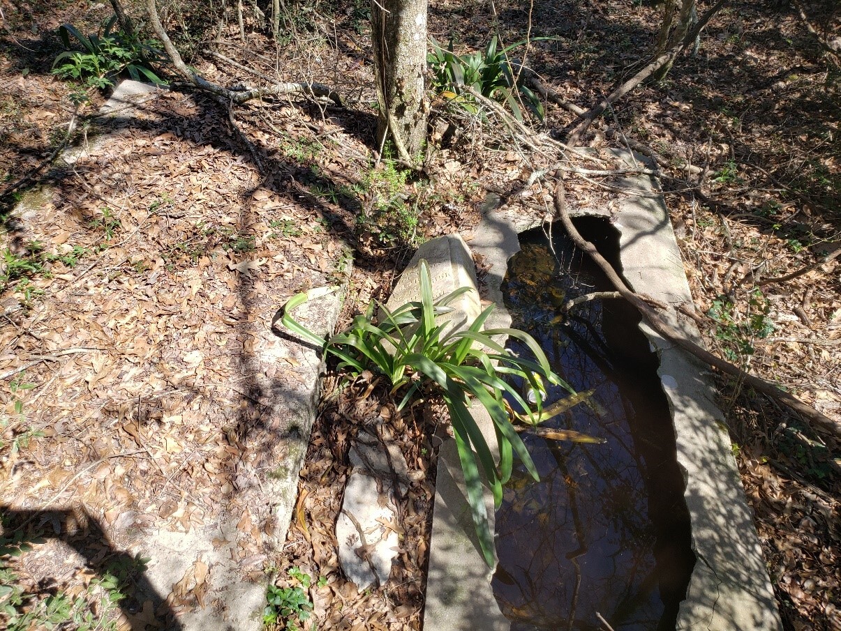
    <summary type="html"><![CDATA[<p><strong><em>Hookman Cemetery began as a peaceful journey's end but turned into a lover's lane horror story and finally to forgotten lore.</em></strong></p><img src="https://mail.acadianahistorical.org/files/fullsize/f59b557bdce8bb27a0344f81aed12bf0.jpg" alt="Broken and Abandoned" /><br/><p>An interesting tale arises concerning a lost and forgotten cemetery named Hookman in Rayne, Acadia Parish. Located on a sharp turn off a gravel road known as Ohlenforst, the only access is a small ATV beaten path and through a small clearing. A total of seven graves scatter the grounds although multiple headstones are partially buried and indiscernible. One site, broken open to the elements, is filled with water and trash. The newest headstone, placed in 1934, clearly shows an abandoned cemetery. Although referred to as Hookman Cemetery, the name resulted from a lover’s lane ghost story concerning a man with a hook. Eventually, the name stuck. Local newspaper clippings reveal the latest burial of Lee Anding and referred to the burial site as McClellan (McClelland) Cemetery. The obituary stated Anding died at the Anding homestead and was a farmer who left behind seven adult children. All but one, Charles Robertson, buried in the cemetery is either a McClelland or an Anding. Census records in 1910 indicate that the McClelland and Anding families lived next door to one another. The history points to a small, family locale cemetery not called Hookman Cemetery, but McClelland Cemetery. The grounds are an open-air Acadian farming family history museum that should be remembered instead of forgotten.</p><p><em><strong><a href="https://mail.acadianahistorical.org/items/show/86">For more (including 7 images&#32;&amp;&#32;1 audio file) view the original article</a></strong></em></p>]]></summary>
    <published>2022-02-18T01:30:53+00:00</published>
    <updated>2026-03-04T22:42:47+00:00</updated>
    <link rel="alternate" type="text/html" href="https://mail.acadianahistorical.org/items/show/86"/>
    <id>https://mail.acadianahistorical.org/items/show/86</id>
    <author>
      <name>Tanya G. Greene</name>
    </author>
  </entry>
  <entry>
    <title type="html"><![CDATA[Hidden Town of Sherburne: Louisiana&#039;s Lumber Towns ]]></title>
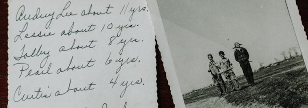
    <summary type="html"><![CDATA[<p><strong><em> Besides the name, the remains left of Sherburne are a few wooden frames of homes, steel equipment and a sawdust pile.    </em></strong></p><img src="https://mail.acadianahistorical.org/files/fullsize/087ffcc8037f39be2538e2e2ecfe5495.jpg" alt="Fletcher family children walking" /><br/><p>LOCATION: POINTE COUPEE PARISH, LA</p><p>COORDINATES: 30.462429, -91.714972</p><p>STATUS: FORGOTTEN AND LOST </p><p>In the 1880s the lumber business came to Louisiana and as the tracts of uncut forest were large, sawmills easily popped up, as the mill itself was able to continue running all day, maximizing the yield and money.  Of these sawmill towns that cropped up for Louisiana one was Sherburne along the Atchafalaya River.  When the lumber business began to dry up towards the end of the later 1800s, the town’s grocer Henry bought up land for farming and to build houses for farmers as the land was now cleared. Come 1939 the federal government ordered the town to move as the construction of the Morganza Spillway might flood the town. Today the Sherburne Wildlife Management Area in the Atchafalaya National Wildlife Refuge (NWR), named in honor of the town that was built there and forced to move, covers where the town stood.  Besides the name, the remains left of Sherburne are a few wooden frames of homes, steel equipment and a sawdust pile.     </p><p><em><strong><a href="https://mail.acadianahistorical.org/items/show/41">For more (including 3 images&#32;&amp;&#32;1 audio file) view the original article</a></strong></em></p>]]></summary>
    <published>2018-04-26T15:41:51+00:00</published>
    <updated>2026-03-04T22:42:46+00:00</updated>
    <link rel="alternate" type="text/html" href="https://mail.acadianahistorical.org/items/show/41"/>
    <id>https://mail.acadianahistorical.org/items/show/41</id>
    <author>
      <name>Rachel Blomquist </name>
    </author>
  </entry>
  <entry>
    <title type="html"><![CDATA[Old City Hall: Lafayette&#039;s First City Hall and National Registered Historic Place]]></title>
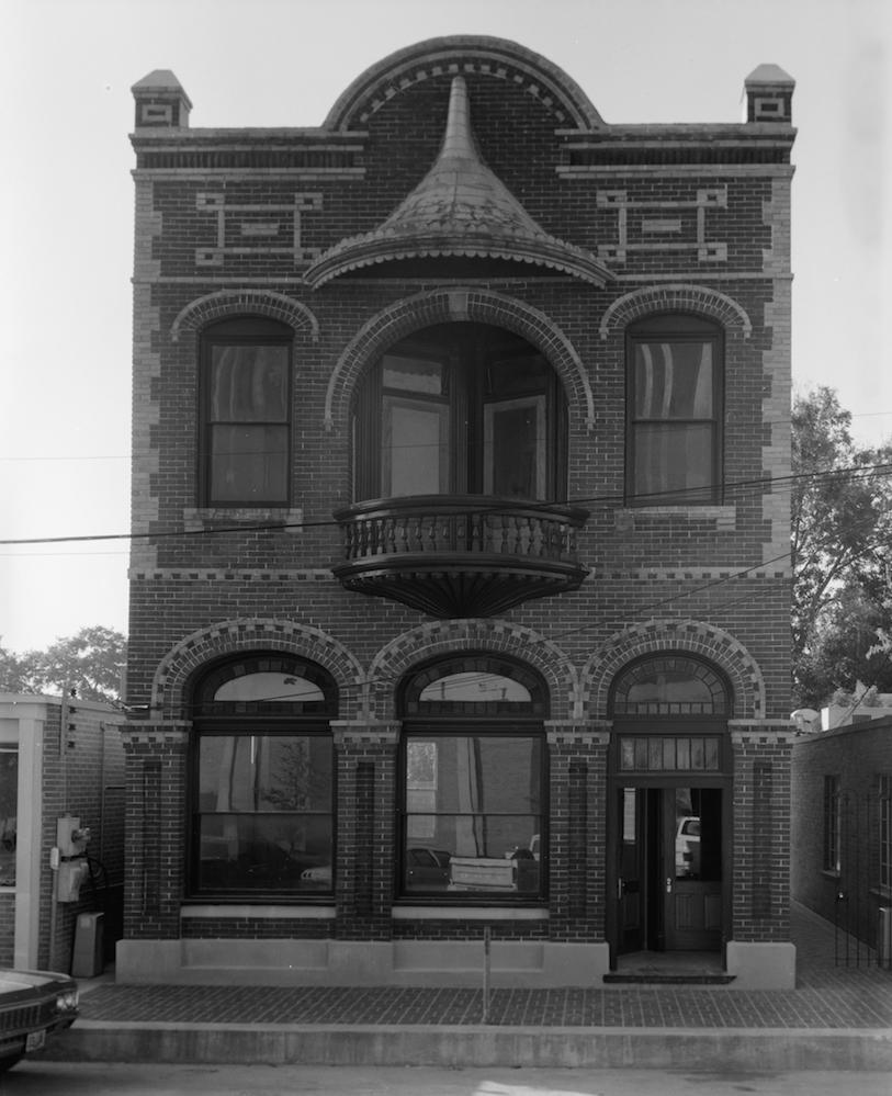
    <summary type="html"><![CDATA[<p><strong><em>One of the first buildings in the town of Lafayette to be on the National Register of Historic Places was, the affectionately nicknamed, Old City Hall.</em></strong></p><img src="https://mail.acadianahistorical.org/files/fullsize/1429932d0b1fb7ce2bbd4322bdde36f0.jpg" alt="1981 City Hall" /><br/><p>LOCATION: LAFAYETTE, LAFAYETTE PARISH, LA</p><p>COORDINATES: 30.222657, -92.020472 (217 W. MAIN ST. LAFAYETTE)</p><p>STATUS: FORGOTTEN </p><p>One of the first buildings in the town of Lafayette to be on the National Register of Historic Places was, the affectionately nicknamed, Old City Hall. It as built in 1898 to be the town’s first bank.  Built in the Rococo style, the building is two stories with colored glass windows and different sized bricks. In 1906, the town of Lafayette bought it and turned it into the city hall. It was the city hall for thirty-three years until 1939.  Then the building went through various owners before there was talk of having the building torn down.  However funds were gathered and the last people to stay in this building were the Council for the Development of French in Louisiana (CODOFIL) in the late 1990s. Since then the building has stood empty amongst it neighbors, waiting for a new owner. </p><p><em><strong><a href="https://mail.acadianahistorical.org/items/show/34">For more (including 4 images&#32;&amp;&#32;1 audio file) view the original article</a></strong></em></p>]]></summary>
    <published>2018-04-26T15:31:42+00:00</published>
    <updated>2026-03-04T22:42:46+00:00</updated>
    <link rel="alternate" type="text/html" href="https://mail.acadianahistorical.org/items/show/34"/>
    <id>https://mail.acadianahistorical.org/items/show/34</id>
    <author>
      <name>Rachel Blomquist</name>
    </author>
  </entry>
</feed>